Skip to content

  • Projects
  • Groups
  • Snippets
  • Help
    • Loading...
    • Help
    • Submit feedback
    • Contribute to GitLab
  • Sign in
M
mirae-wave-manual
  • Project
    • Project
    • Details
    • Activity
    • Releases
    • Cycle Analytics
  • Repository
    • Repository
    • Files
    • Commits
    • Branches
    • Tags
    • Contributors
    • Graph
    • Compare
    • Charts
  • Issues 0
    • Issues 0
    • List
    • Board
    • Labels
    • Milestones
  • Merge Requests 0
    • Merge Requests 0
  • CI / CD
    • CI / CD
    • Pipelines
    • Jobs
    • Schedules
    • Charts
  • Wiki
    • Wiki
  • Snippets
    • Snippets
  • Members
    • Members
  • Collapse sidebar
  • Activity
  • Graph
  • Charts
  • Create a new issue
  • Jobs
  • Commits
  • Issue Boards
  • MiraeDEV
  • mirae-wave-manual
  • Wiki
  • 3 5 control boundary

3 5 control boundary

Last edited by Trang Hoang Sep 05, 2017
Page history

Controlling regional boundaries (and how to use Area Pane)

![](img/3-5-area-pane.png)

The Area Pane shows the map area or cross-section position of the selected layers.

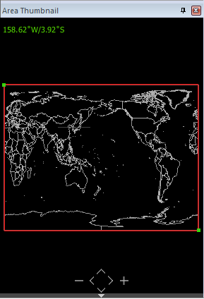
  • For Scalar Horizontal and Vector Horizontal layers, the map area is shown as a rectangle.
  • For Scalar Cross-section and Vector Cross-section layers, the cross-section position is shown in a line.

The Area Pane shows the whole map, by default. You can control the regional boundary of the map area or the cross-section position as follows.

Zooming in/out or moving the map area

  • You can enlarge or reduce the map area by clicking the - or + icons at the bottom of the Area Pane.

  • You can move the map area by clicking the Left (<), Right (>), Up (^), Down (v) icons.

You can also scroll or drag your mouse to zoom in/out or move the map area.

Changing the layer position/area

When the mouse cursor is placed on the border line map in the Area Pane, it displays the longitude/latitude of the cursor position in the top-left of the Area Pane. It also displays the start and end points of the map area or cross-section position as green dots (control handles).

To change the map area or the cross-section position, place the mouse at start and end points (control handles) of the rectangle or the cross-section position, and drag the points to the desired positions.


Previous Page Home (Table of Contents) Next Page
Clone repository
  • 1 1 introduction
  • 2 1 installation
  • 2 2 sample data
  • 2 3 license
  • 3 1 ui components
  • 3 2 open data
  • 3 3 open layer
  • 3 4 control perspective
  • 3 5 control boundary
  • 3 6 action history
  • 4 1 horizontal scalar field
  • 4 2 vertical scalar field
  • 4 3 horizontal vector field
  • 4 4 vertical vector field
  • 4 5 isosurface
More Pages

New Wiki Page

Tip: You can specify the full path for the new file. We will automatically create any missing directories.